 They had both lived here previously, years ago, so they weren’t entirely inexperienced in the ways of the city. Still, even for those who have lived here before, finessing a move here can be challenging, and they’ve often impressed me with the ease with which they’ve made their transition. For one, they’ve shown tremendous resourcefulness in navigating the subway system, finding unique and efficient ways of getting from their out-of-the-way neighborhood in Brooklyn to various points around the city. They finally shared their secret with me: HopStop.com.
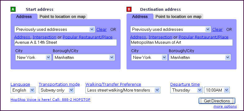 As with MapQuest, you just enter your starting and ending points, and the site generates detailed directions from point A to point B. It tells you how to get to the nearest subway station, the transfers you need to make, and how to walk from your subway stop to your ultimate destination. What if you don’t know the address of the Met? No problem; just type in “Metropolitan Museum of Art.” You can also use intersections, but the system won’t recognize a single street only (e.g., you must put in 14th St. & Avenue A” – not merely “14th St.”). You can use pull-down menus to select such preferences as whether to walk more and transfer less (or vice-versa), and whether to combine bus and subway options. You can also enter the day and time you’ll be making the trip and select a language for the directions (current options are English, Chinese, French, German, Greek, Italian, Russian, Spanish and Swahili).
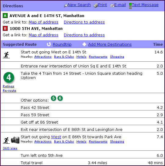 If you don’t like the route it suggests, just click “Reroute” and HopStop provides alternate directions. Or if you want to know how safe, clean, efficient, etc., the subway or bus line is, just click “Ratings” to get Zagat-like user reviews and tips. Once you have your route, you can text-message it, email it or print it. Other site features include the ability to generate an itinerary with multiple stops, maps, and guides to nearby attractions, shops and restaurants.
Even if you know the subway system like the back of your hand, HopStop.com is a great asset when you’re hosting the inevitable out-of-town visitor. Just text-message them an itinerary, and you may never get another desperate “OMG, we’re lost!” phone call again.
2 comments:
Wow, a real help! Wish I'd known about this for years!!!
Thanks, Erik! That site is a huge time-saver. Thanks again for reading!
Post a Comment