Part of Manhattan's charm is the distinct character of each neighborhood, from Murray Hill to Morningside Heights, Little Italy to Lenox Hill. Check in here for neighborhood guides and info; I’ll periodically update these links to keep you informed.
Neighborhood Spotlights and Local Attractions
Spotlight on Morningside Heights: A Walking Tour
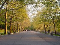 Morningside Heights – so named because it sits atop a 135-foot bluff - is a genteel neighborhood just above Manhattan's Upper West Side. Flanked by three of the city's finest parks, and home Columbia University and The Cathedral of St. John the Divine, it lends itself to meandering and taking your time. Get to know the people and places of Morningside Heights on this walking tour.
Spotlight on Midtown: One Night at the Plaza
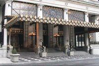 An anchor on the northern edge of Midtown, the Plaza Hotel was the Grande Dame of New York luxury hotels. Established in 1907, its rooms overlooking Central Park, its French Chateau architecture, and its famed interiors such as the Palm Court, the Grand Ballroom and the Oak Room and Oak Bar made the Plaza a New York icon. Sadly, the hotel closed its doors on April 30, 2005, for a conversion to private residences.
Greenmarkets: A Guide to Farmer's Markets in NYC
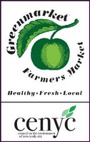 You probably already know about the popular Union Square Greenmarket (or Farmer's Market, as it's often called). But did you know Manhattan hosts 18 other Greenmarkets throughout the city on different days of the week? While some are seasonal, 11 are open year-round. Use this map to find a Greenmarket in your neighborhood. NOTE: Adobe Acrobat Reader required. For more information on the city’s Greenmarket program, CLICK HERE.
NYC's Architectural Gems by Neighborhood
Tom Fletcher, a New York architect (by way of Australia), maintains this online library of photographs and notes about an eclectic range of the city's most architecturally interesting buildings; it's conveniently organized by neighborhood.
Best Neighborhoods for Inline Skating
This handy neighborhood guide to best places for inline skating is thoughtfully written for the novice as well as experienced skater, noting such details as how the trees hanging over the sidewalks of Riverside Park make the ground "twiggy." Get the full rundown on all the best locales around Manhattan.
Manhattan Restaurants by Neighborhood
When you need a restaurant in a specific neighborhood, use this link to get New York Magazine’s listing of 1,861 Manhattan restaurants sorted by location – from Battery Park City to the West Village (neighborhoods are sorted in alphabetical order). You can resort the list by cuisine, price range or restaurant name. Reviews are included, too.
New York Magazine Neighborhood Guides
The glossy’s Web site offers a number of handy neighborhood guides with detailed maps and write-ups on local shops, restaurants and attractions. Check them out before you head out.
SoHo
Map No 5: Crosby Street (November 29, 2004)
Lower East Side
How Low Can You Go? (May 8, 2006)
Lower East Side-East Village
Map No 2: The Bowery (October 25, 2004)
Union Square
Map No. 9: State of the Union (April 5, 2005)
Upper East Side
Map No 4: Lexington Avenue (November 29, 2004)
Upper West Side
Map No 1: Lower-Middle-Upper West Side (October 6, 2004)
Harlem
Map No 8: 125th Street (February 28, 2005)
Maps and Community Information
New York City Map Portal: Community Information by Address
 Plug your address into this interactive NYC Map Portal, and you can spend hours getting detailed information on your neighborhood, from the breakdown of your various districts (community, city council, school, etc.), census data and local services to a host of statistics such as crime rates, number of noise complaints and more.
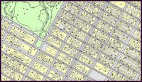
Map of Manhattan Neighborhoods
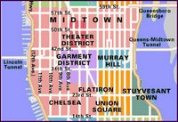 This color-coded map demarcates where one Manhattan neighborhood ends and the next begins, from Inwood to the Financial District.
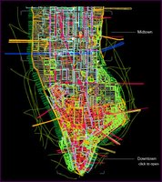
City of Neighborhoods: The NYC Department of City Planning Interactive Neighborhood Map
This map breaks the five boroughs down into their 59 official Community Districts. Click on any one to get a detailed view of the district, including niche neighborhoods (e.g., you’ll see not just the Upper East Side, but Carnegie Hill). Or, use the pull-down menu to select a specific neighborhood to view. You can also use this site to obtain information on proposed city planning projects, such as the city’s recommendations for the development of the World Trade Center site and the High Line development plan in Chelsea.
Manhattan Timeformations: The NYC Skyline in 3D
 Watch this interactive computer animation reveal the development of the downtown New York City skyline, neighborhood-by-neighborhood and era-by-era. First click on an area (e.g., downtown), then click through the time periods and major developments, and watch the city take shape – literally. HINT: A brief tutorial precedes the animation; just click through each of the links to arrive at the interactive map. For more information about the Manhattan Timeformations project and its developers, CLICK HERE.
The Oldest Known Map of Manhattan (1639)
For a look at Manhattan long before the skyscrapers, check out this 1639 map, dotted with tiny farms, plantations and four Native American villages in what is now Brooklyn.

 An anchor on the northern edge of Midtown, the Plaza Hotel was the Grande Dame of New York luxury hotels. Established in 1907, its rooms overlooking
  You probably already know about the popular Union Square Greenmarket (or Farmer's Market, as it's often called). But did you know
  Plug your address into this interactive NYC Map Portal, and you can spend hours getting detailed information on your neighborhood, from the breakdown of your various districts (community, city council, school, etc.), census data and local services to a host of statistics such as crime rates, number of noise complaints and more.
 This color-coded map demarcates where one
  Watch this interactive computer animation reveal the development of the downtown
No comments:
Post a Comment